New Jersey Shore
to Home
August 30, 2005
By Colby MungerAs I write
this log we are home in
Crownsville just outside of
Annapolis, Maryland and MYSTIC
ROSE is secure in her slip in
Salt Works Creek on the Severn
River. We are watching the
new reports of the devastation
caused by Hurricane Katrina in
New Orleans and the surrounding
areas and feeling thankful that
we are safely home. Our
trip down the New Jersey coast
had some unpleasant aspects but
nothing compared to what people
are experiencing on the Gulf
Coast.
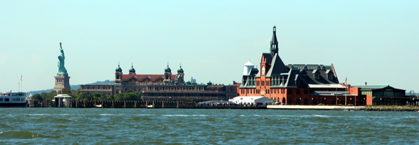
On Wednesday, August 24, We
left Haverstraw on the Hudson
River and headed south through
New York City. The weather
was great as you can see in the
picture above showing the Ferry
Terminal, Ellis Island and the
Statue of Liberty all lined up
in beautiful afternoon light.
We left the harbor and crossed
to Atlantic Highlands for diesel
fuel where fuel prices much
cheaper than in New York.
Afterwards we returned to Staten
Island's Great Kill and stayed
at Nichols State Park Marina for
the night.
A cold front had passed
through New York on Tuesday and
settled across the Carolinas.
We always look for a high dome
over the New Jersey coast
because it has the best promise
for light winds. If you
can catch the end of the
northerlies before the wind
turns southerly behind the high,
there is also a reduced chance
of fog around Cape May.
NOAA had promised northerly wind
at ten knots with 2 to 3 foot
seas on Thursday. The wind
was to go variable and fill in
from the south on Friday.
Thursday looked promising for a
run south along the coast to
Cape May.
In the Great Kill the wind
died down at sunset and we felt
that was a good sign. At
4am I was awakened by small
waves lapping at the bow.
I got up and checked the wind
instrument and there was 11
knots out of the northwest.
I convinced myself that it was
probably just a catabolic
offshore breeze caused when the
land cools below the sea
temperature and an offshore
circulation can develop.
We were up for a sunrise
departure. The wind was up
13 knots.
Heading South
We rounded Sandy Hook and
headed south. The seas
were 3 feet and confused.
Confused seas are typical around
Sandy Hook. We were
heading off seas at 17 knots
when we felt a shutter pass
through the boat. We
slowed and backed the boat to
shake anything that might have
fouled the prop. We came
up to 15 knots and everything
seemed fine. This is the
second time we had felt the
shutter and believe that it can
happen in confused following
seas and the boat is overtaking
the seas at too high a speed.
It's possible that as the boat
crests a wave the confused seas
astern can can force air under
the stern and allow the prop to
ventilate. Props really
don't like an air-water mixture.
After slowing slightly we never
experienced the shutter again
and though we didn't know it at
the time, the seas were going to
get worse.
The wind build to between 15
and 17 knots with gusts to
twenty. The seas were now
three feet with occasional four
footers. The autopilot
dealt with the steering fine and
the ride was tolerable.
Twenty eight miles south of
Sandy Hook is Manasquan Inlet,
one of the possible harbors of
refuge. With these
conditions Carol and I decided
to press on. Most cruisers
consider Absecon Inlet at
Atlantic City the next chance to
get off the Ocean. Absecon
Inlet is approximately 65 miles
further, more than four hours
south of Manasquan Inlet.
Within an hour the winds
built to a steady 20 knots out
of the northeast with gusts to
27. I had to slow the boat
speed so that the boat would not
surf down the large waves to
bury the bow in the next wave.
Good boat speed is needed to
keep reasonable steering control
as the quartering seas also try
to broach the boat. I
found a speed that balanced
these two competing needs and
was glad that the autopilot was
dealing with the conditions.
I was willing to hand steer but
given the distance we needed to
cover, I wanted to save hand
steering for when and if it was
really needed.
The seas were now four to six
feet with occasional seven
footers. Carol informed me
that she wasn't having fun.
Six miles to the south of us
and 30 miles south of Manasquan
Inlet is Barnegat Inlet.
This is one of the inlets that
shows no buoys on the chart
marking the entrance channel.
A look at the notes reveals that
the channel shifts so quickly
that the marks are always being
changed... swell. It
explains why most cruising
guides ignore Barnegat Inlet as
a refuge. I was looking at
Barnegat Light thinking it would
be nice to pull in here and get
out of this yuck when a heard a
call to the Coast Guard from a
sailboat.
The sailboat was asking about
conditions in the Inlet.
SeaTow answered the call and
said the Inlet was easily
managed and described the
channel marks and gave
directions to an anchorage and
an available marina. I was
all over it. We contacted
SeaTow, said we heard the
conversation and planned on
coming in also. They put
us in touch with High Bar Harbor Yacht
Club which could put us up so in
we started.
The inlet runs northwest
which put the seas on our beam.
MYSTIC ROSE handled it fine
though the skipper had left the
hatch over his head in the first
detent which provides a 3/8 inch
opening for some breeze. A
seven footer crashed into the
starboard beam. The boat
shrugged it off but it's amazing
how much water can pour through
a slightly open hatch.
Carol had no sympathy for my
dampness or stupidity.
Inside the inlet all was
calm. In all, five boats
took advantage of guidance from
SeaTow and came in during that
hour. We really
appreciated the courtesy and
professionalism shown by their
crews in Barnegat Inlet.
We were tied up in a comfortable
slip in time for lunch. We
had only been underway for five
hours though the skipper felt a
few years older.
A fifteen minute walk from
the marina there is professional
fishing fleet dock with an
attached Deli. I had the
best tasting grilled scallops I
have ever experienced.
Food always better after a good
thrashing though being thrashed
is not a recommended method for
enhancing the pallet.
Barnegat Inlet to Cape May
Friday dawned calm with a
four knot wind out of the west,
not like the wind in the Great
Kill the day before. This
was a real catabolic land
breeze. The high dome was
on top and the real
weather window had arrived.
We were out at sunrise for the
65 nautical mile run to Cape
May. What a difference a
day can make. It was calm
giving into a slight southerly
at less than six knots.
This kind of boating is nice.
While heading south we
reviewed the weather NOAA
promised for the next day on
Delaware Bay. The winds
were to fill in from the
southeast and increase to 15
knots generating 3 foot seas in
the lower bay. If the
winds arrived early it could
provide a lumpy ride. We
decided that if the wind was
still calm when we got to Cape
May we would refuel and continue
on to the Chesapeake Bay that
same day.
We entered the Cape May
breakwater at 10:30am The seas had
been calm the entire way.
We pulled into the Canyon Club
fuel dock and took on 150
gallons. They let us stay
tied while we ate lunch and at
12pm we were underway heading
out the back channel to Delaware
Bay.
Continuing on to the
Sassafras River
The Delaware Bay was calm and
the flood tide was just
beginning. As the tide
changes come later as you
proceed northwest up the Bay we
had a favorable current all the
way to the C&D canal. For
half the time we were making 19
knots over the ground with only
17 knots through the water.
As we turned into the C&D canal
the tide went slack and the
current was neutral all the way
to the Sassafras River on the
Chesapeake Bay. By 5:30pm
we were tied up at the Sassafras
Harbor Marina 85 miles from Cape
May. We had made our
longest single day run, 150
nautical miles. With our
thrashing the day before and the
long run today we were a little
tired.
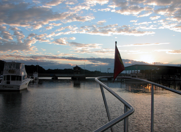 After
a nice dinner at the Granary
Restaurant we were soon asleep.
The next morning we awoke to the
sunrise at the right and
considered whether to do the
last 42 miles home this
morning or lay over.
Showers were promised for later
in the day with thunder showers
on Sunday and Monday. The
remnants of Hurricane Katrina
were promised for mid week.
We thought we would clean up in
the morning from our last two
days and head home. After
a nice dinner at the Granary
Restaurant we were soon asleep.
The next morning we awoke to the
sunrise at the right and
considered whether to do the
last 42 miles home this
morning or lay over.
Showers were promised for later
in the day with thunder showers
on Sunday and Monday. The
remnants of Hurricane Katrina
were promised for mid week.
We thought we would clean up in
the morning from our last two
days and head home.
Water Spout off Pooles
Island
Shipshape, we took in our
lines at 9:30am and headed out the
Sassafras River watching local
storm cells building north and
south. It looked
temporarily clear west towards
the mouth of the river.
After reaching the Bay we turned
south. The wind built to
20 knots and the the sky looked
ominous to the west. The
clouds were moving north and it
looked to clear us.
When we were abeam of Pooles
Island a boater announced that a
water spout had touched down
just north of Pooles Island.
The Coast Guard came on in a few
minutes and passed the
warning on to everyone on the
Bay. We were beginning to
wonder if we had annoyed Neptune
by being out cruising for only
three months. Our weather
and cruising conditions had been
pretty much ideal up to the last
few days.
We couldn't see the water
spout that was suppose to be
pretty close to our position but
we checked the charts quickly
for a safe haven. Whorton
Creek was just to southeast so
we headed toward there until the
storm resolved itself. We
hadn't gone far before the cell
continued north and the southern
horizon brightened so we
continued on towards the Bay
Bridge.
In less than two hours we
were maneuvering around three
sailboat races and weaving
through crab pots at the mouth
of the Severn River. A
light rain was falling and our
homeport never looked so good.
We were soon tied up in our home
slip in Salt Works Creek off the
Severn and making lunch.
The trip home from Essex, New
York on Lake Champlain had taken
eight days.
The last three days won't go down as the
favorites of our cruise but the
cruise will go down as the best
cruise of our lives so far.
I hope you have enjoyed
traveling with us through this
online
log.
We have begun to settle into
living in the house again but
after Katrina passes by we are
planning three nights and four
days cruising the Eastern Shore
over Labor Day weekend. In
the end you can't get enough
cruising. |